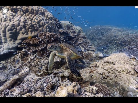
You may recall back in 2010 that Google Street View extended to parts of Antarctica. Now they’re going a step further and taking us underwater to explore Australia’s Great Barrier Reef. Thanks to a partnership between the Catlin Seaview Survey and Google Maps, it’s now possible to observe the reef just as divers do.
Specially adapted underwater tablet-operated cameras are collecting more than 50,000 360-degree images from Australia, the Philippines and Hawaii in a bid to create virtual maps of the oceans, share some wonders of the world and show the state of fragile ecosystems over time.
Paul Johnson is Editor of A Luxury Travel Blog and has worked in the travel industry for more than 30 years. He is Winner of the Innovations in Travel ‘Best Travel Influencer’ Award from WIRED magazine. In addition to other awards, the blog has also been voted “one of the world’s best travel blogs” and “best for luxury” by The Telegraph.
Did you enjoy this article?
Receive similar content direct to your inbox.
2 Comments
That is so very cool.. although nothing beats actually diving on the reef and seeing all the creatures up close
Comments are closed.
Subscribe!
Subscribe today to get our weekly newsletter! You don’t want to miss out!
 Specially adapted underwater tablet-operated cameras are collecting more than 50,000 360-degree images from Australia, the Philippines and Hawaii in a bid to create virtual maps of the oceans, share some wonders of the world and show the state of fragile ecosystems over time.


 Specially adapted underwater tablet-operated cameras are collecting more than 50,000 360-degree images from Australia, the Philippines and Hawaii in a bid to create virtual maps of the oceans, share some wonders of the world and show the state of fragile ecosystems over time.

That is so very cool.. although nothing beats actually diving on the reef and seeing all the creatures up close