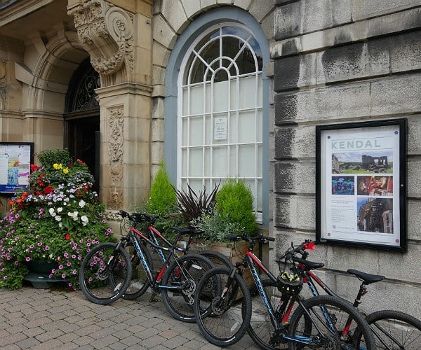
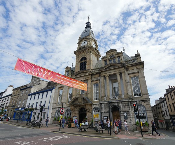
Starting just outside the Lake District National Park in the centre of the market town of Kendal, this mountain bike ride enjoys a mixture of mostly quiet roads and a variety of off-road terrain. We tackled the route on the robust Ridgeback MX4, an entry level mountain bike fitted with Shimano gearing and capable of taking on a variety of different terrain.
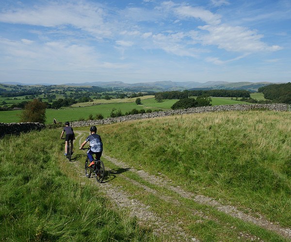
A hilly road climb to the west of Kendal (the same hill that is used for finish for the Gateshead to Kendal stage of the Tour of Britain cycle race) eventually sees you leave the road at Gamblesmire Lane and move on to a stoney track with most of the first of the two most significant climbs of this route completed.
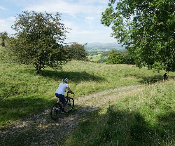
Here you are between the limestone escarpments of Cunswick Scar and Scout Scar and the landscape opens out with some lovely views of rolling South Lakeland fells.
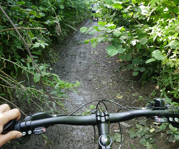
In places further on, the track becomes quite narrow – brace yourself for a few nettle stings and the occasional bramble scratch!
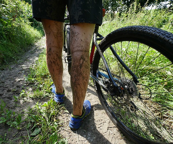
It was a warm, sunny day and we had just returned from Switzerland so were a little oblivious to what the recent weather had been like in the north of England. We soon discovered that there must have been rain as the path went into a shaded area and we encountered some wet and boggy stretches.
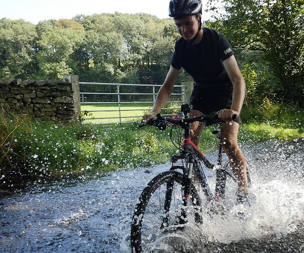
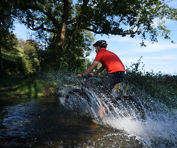
The highlight of the ride was the ford we went through as we took the loop around Bell Hill. Again, this suggested there had been plenty of rain as there was no getting through this without getting a little wet…
…unless, of course, you took the footbridge instead, but where’s the fun in that?!
After a short climb, I enjoyed the descent that followed until we finally returned to some sense of civilisation – a few houses initially, soon followed by Underbarrow church and Underbarrow itself.
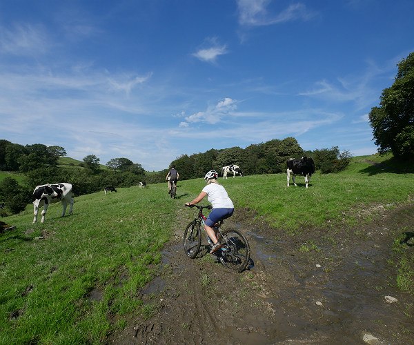
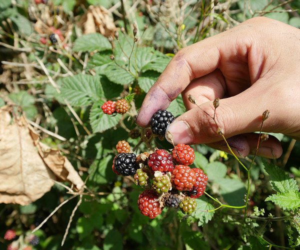
It was a hot day and by this time our water supplies were getting quite low; we knew we could get refills at one of the pubs on the route so were not too concerned, but the blackberries in the hedgerows were starting to ripen and provided us with a little sustenance to keep us going.
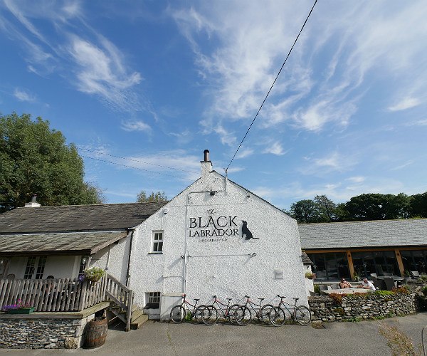
There are two pubs in quick succession where you can stop for refreshment. The first is the Black Labrador at Underbarrow, formlerly known as The Punchbowl but presumably its name change was in part down to the fact that there is another Punchbowl in the neighbouring village of Crosthwaite.
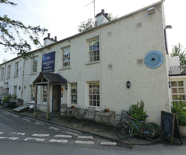
The second, about a mile further on, is The Wheatsheaf at Brigsteer, which proudly displays a large ‘cyclists welcome’ sign.
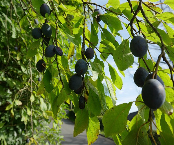
This is Lyth Valley territory – an area famous for its damsons. Keep your eyes peeled and you may just see some. Or visit in April and you could attend the Damson Day country fair which takes place annually and celebrates all things damsons, including damson gin and damson jelly, as well as various other Cumbrian traditions.
A final climb up to the church of St. John’s at Helsington is soon followed by a bridleway and a farm road, before taking you back into Kendal along the A6 where you can finish at the starting point of Kendal Town Hall.
If you would like to follow this route for yourself, you can find written directions as well as a GPX file that you can download to your smartphone, by visiting this link at pedalnorth.com.
Disclosure: The bikes were kindly supplied to us by Ridgeback who introduced mountain biking to the UK in the early 1980s.
Paul Johnson is Editor of A Luxury Travel Blog and has worked in the travel industry for more than 30 years. He is Winner of the Innovations in Travel ‘Best Travel Influencer’ Award from WIRED magazine. In addition to other awards, the blog has also been voted “one of the world’s best travel blogs” and “best for luxury” by The Telegraph.
Did you enjoy this article?
Receive similar content direct to your inbox.
11 Comments
One of my birthday presents was a jar of Fortnum and Masons Damson and Gin jam, a heavenly combination, so the damsons’ fame is spreading far and wide.
Damsons have grown in the area since the early 1700s. They were very popular for jam during the second World War but that popularity waned until comparatively recently (last 20-30 years) when demand – for all kinds of purposes, gin included! – has seen something of a resurgence.
Did you do this last weekend? The mud-splattered legs make me think it could have been. Then again there’s too much sunshine for last weekend. Also most blackberries now are a little riper than those. Sorry, having a bit of a Sherlock Holmes moment.
No, it was actually late August but I’ve had a backlog of writing up to do, following recent trips to Switzerland and Kazakhstan. :)
At long last a lot of country pubs are realising that they are in the country and that many of their customers will be muddy and sweaty. People enjoying the countryside do have a tendency to get a bit messy but that’s not a reason to stop them coming into the pub. If only there were more cyclists and walkers welcome signs around.
I think pubs have had it pretty tough over the last couple of decades that they need to think ‘outside the box’ for how they attract their custom… particularly country pubs. It seems simple business sense to me that if you’re on popular walking or cycling routes that you embrace that potential custom.
There are still a lot of people around who like their countryside to be chocolate box / birthday card twee. I’ve got news for them. The countryside is for work for the farmers and for play too for the bikers and hikers. If you head out into the countryside you will get your hands and boots dirty. I’m pleased that so many country pubs are becoming more real world about what goes on around them.
Some great photos here, and the trails sound great for a little adventure. I agree, it’s more fun when it’s a little rugged and wet and muddy. I know a few avid cyclists so I’ll pass this article on as it’s always good to get fresh ideas of new places to explore. And you’ve done the hard work for them by picking out the pub stops, arguably the most important part of the biking journey! It’s brilliant you can actually download the directions for the route, I hope more places do this for cycling and walking trails as it would be very handy to have.
Thank you for sharing it, Simone! It’s actually pretty common to be able to download routes. If you use something like Strava and have the right attachment on your bike, you can actually follow the route very easily as you cycle (a bit like a sat nav). Unfortunately, I don’t have the attachment, so it was just a case of getting my phone out of my pocket every now and again to check that we were still on course). Also, always a good idea to take a map with you as well and not rely solely on the technology just in case of any technical issues.
I hadn’t realised that. It’s great how technology can be so versatile but I totally agree, I wouldn’t want to rely solely on it either so I’d always want a back up map or any printed guides and instructions ‘just in case’. I’m the same with walking trails so even if I’ve got something on my phone and I’m using GPS, which is amazing, I still take handwritten notes on where I’m going and a physical map. Don’t want to tempt fate and have a tech emergency!
True that!!! No matter how advance technology has progressed, it is definitely not something to solely depend on. Even the thought of being lost in a dense forest with your phone or pocket wifi’s battery running out send chills down the spine. So it’s best to be equipped with all the non-tech essentials as back-up while travelling- regardless of how chic or appealing gadgets you own. The smart move is to always come handy with a more sustainable and reliable option particularly when you are all set for adventures like hiking or mountain biking.
 A hilly road climb to the west of Kendal (the same hill that is used for finish for the Gateshead to Kendal stage of the Tour of Britain cycle race) eventually sees you leave the road at Gamblesmire Lane and move on to a stoney track with most of the first of the two most significant climbs of this route completed.
 After a short climb, I enjoyed the descent that followed until we finally returned to some sense of civilisation – a few houses initially, soon followed by Underbarrow church and Underbarrow itself.

 A hilly road climb to the west of Kendal (the same hill that is used for finish for the Gateshead to Kendal stage of the Tour of Britain cycle race) eventually sees you leave the road at Gamblesmire Lane and move on to a stoney track with most of the first of the two most significant climbs of this route completed.
 Here you are between the limestone escarpments of Cunswick Scar and Scout Scar and the landscape opens out with some lovely views of rolling South Lakeland fells.
 In places further on, the track becomes quite narrow – brace yourself for a few nettle stings and the occasional bramble scratch!
 It was a warm, sunny day and we had just returned from Switzerland so were a little oblivious to what the recent weather had been like in the north of England. We soon discovered that there must have been rain as the path went into a shaded area and we encountered some wet and boggy stretches.
 The highlight of the ride was the ford we went through as we took the loop around Bell Hill. Again, this suggested there had been plenty of rain as there was no getting through this without getting a little wet…
 …unless, of course, you took the footbridge instead, but where’s the fun in that?!

 It was a hot day and by this time our water supplies were getting quite low; we knew we could get refills at one of the pubs on the route so were not too concerned, but the blackberries in the hedgerows were starting to ripen and provided us with a little sustenance to keep us going.
 There are two pubs in quick succession where you can stop for refreshment. The first is the Black Labrador at Underbarrow, formlerly known as The Punchbowl but presumably its name change was in part down to the fact that there is another Punchbowl in the neighbouring village of Crosthwaite.
 The second, about a mile further on, is The Wheatsheaf at Brigsteer, which proudly displays a large ‘cyclists welcome’ sign.
 This is Lyth Valley territory – an area famous for its damsons. Keep your eyes peeled and you may just see some. Or visit in April and you could attend the Damson Day country fair which takes place annually and celebrates all things damsons, including damson gin and damson jelly, as well as various other Cumbrian traditions.
 A final climb up to the church of St. John’s at Helsington is soon followed by a bridleway and a farm road, before taking you back into Kendal along the A6 where you can finish at the starting point of Kendal Town Hall.
 If you would like to follow this route for yourself, you can find written directions as well as a GPX file that you can download to your smartphone, by visiting this link at pedalnorth.com.
Disclosure: The bikes were kindly supplied to us by Ridgeback who introduced mountain biking to the UK in the early 1980s.
If you would like to follow this route for yourself, you can find written directions as well as a GPX file that you can download to your smartphone, by visiting this link at pedalnorth.com.
Disclosure: The bikes were kindly supplied to us by Ridgeback who introduced mountain biking to the UK in the early 1980s.
One of my birthday presents was a jar of Fortnum and Masons Damson and Gin jam, a heavenly combination, so the damsons’ fame is spreading far and wide.
Damsons have grown in the area since the early 1700s. They were very popular for jam during the second World War but that popularity waned until comparatively recently (last 20-30 years) when demand – for all kinds of purposes, gin included! – has seen something of a resurgence.
Did you do this last weekend? The mud-splattered legs make me think it could have been. Then again there’s too much sunshine for last weekend. Also most blackberries now are a little riper than those. Sorry, having a bit of a Sherlock Holmes moment.
No, it was actually late August but I’ve had a backlog of writing up to do, following recent trips to Switzerland and Kazakhstan. :)
At long last a lot of country pubs are realising that they are in the country and that many of their customers will be muddy and sweaty. People enjoying the countryside do have a tendency to get a bit messy but that’s not a reason to stop them coming into the pub. If only there were more cyclists and walkers welcome signs around.
I think pubs have had it pretty tough over the last couple of decades that they need to think ‘outside the box’ for how they attract their custom… particularly country pubs. It seems simple business sense to me that if you’re on popular walking or cycling routes that you embrace that potential custom.
There are still a lot of people around who like their countryside to be chocolate box / birthday card twee. I’ve got news for them. The countryside is for work for the farmers and for play too for the bikers and hikers. If you head out into the countryside you will get your hands and boots dirty. I’m pleased that so many country pubs are becoming more real world about what goes on around them.
Some great photos here, and the trails sound great for a little adventure. I agree, it’s more fun when it’s a little rugged and wet and muddy. I know a few avid cyclists so I’ll pass this article on as it’s always good to get fresh ideas of new places to explore. And you’ve done the hard work for them by picking out the pub stops, arguably the most important part of the biking journey! It’s brilliant you can actually download the directions for the route, I hope more places do this for cycling and walking trails as it would be very handy to have.
Thank you for sharing it, Simone! It’s actually pretty common to be able to download routes. If you use something like Strava and have the right attachment on your bike, you can actually follow the route very easily as you cycle (a bit like a sat nav). Unfortunately, I don’t have the attachment, so it was just a case of getting my phone out of my pocket every now and again to check that we were still on course). Also, always a good idea to take a map with you as well and not rely solely on the technology just in case of any technical issues.
I hadn’t realised that. It’s great how technology can be so versatile but I totally agree, I wouldn’t want to rely solely on it either so I’d always want a back up map or any printed guides and instructions ‘just in case’. I’m the same with walking trails so even if I’ve got something on my phone and I’m using GPS, which is amazing, I still take handwritten notes on where I’m going and a physical map. Don’t want to tempt fate and have a tech emergency!
True that!!! No matter how advance technology has progressed, it is definitely not something to solely depend on. Even the thought of being lost in a dense forest with your phone or pocket wifi’s battery running out send chills down the spine. So it’s best to be equipped with all the non-tech essentials as back-up while travelling- regardless of how chic or appealing gadgets you own. The smart move is to always come handy with a more sustainable and reliable option particularly when you are all set for adventures like hiking or mountain biking.